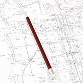
GEODESY

› Geodetic Networks for Local Purpose (GMMP);
› Working Geodetic Fundamentals (WGF);
› Construction networks;
› Special purpose geodetic networks.
› Topographic geodetic photographs;
› Executive photos of buildings and facilities;
› Preparation of transverse and longitudinal profiles for linear infrastructure and facilities;
› Specific geodetic photographs.
› On property boundaries;
› On building contours;
› On axes and structural elements of buildings and facilities;
› Routing during the construction of buildings, facilities and linear infrastructure.
CADASTRE
› Creation of CC and CG, according to the Law on the Protection of Civil and Commercial Property;
› Creation of specialized maps;
› Updating and amending CC and KR – projects for division (partition), unification, elimination of obvious factual errors, filling in buildings and independent objects of property (SOS), certificates under Art. 54a, para. 3 of the ZKIR;
› Combined sketches.
› Updating and amending cadastral plans – projects for division (subdivision), unification, elimination of obvious factual errors, completion of buildings and facilities;
› Digitization and analysis of the accuracy of cadastral plans.
› Agreements for the use of agricultural land under Art. 37c and Art. 37g of the Agricultural Land Use Act.
DETAILED LAYOUT PLANS
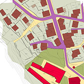
› Preparation of RP;
› Preparation of a motivated proposal for partial amendment of the RP in connection with Art. 35, para. 2 of the ZTA;
› Preparation of drafts for partial amendments to the RP.
› Preparation of the CP;
› Preparation of drafts for partial amendments to the CP.
› Preparation of preliminary and final drafts of the PP for the elements of the technical infrastructure outside the borders of urbanized territories;
› Preparation of expert appraisals of real estate in connection with the purchase, alienation and introduction of easement rights on land properties;
For the listed detailed development plans, we can engage in coordination and approval procedures, as well as a procedure for changing the purpose of agricultural land for non-agricultural needs, in accordance with the Land Use and Development Act.
DESIGNING

› Preparation of projects for vertical planning of internal neighborhood spaces;
› Preparation of projects for vertical planning of street networks and leveling projects;
› Preparation of cartograms of land masses;
› Preparation of bills of quantities.
› Preparation of routing plans for vertical planning projects of newly designed buildings, facilities and infrastructure.
› Design of networks of control, output and monitored points;
› Preliminary assessment of the accuracy of planning and elevation networks and measurements – optimization;
› Analysis and recommendations for:
- types of measurements
- types of tools and number of operators Text
- measurement scheme
- measurement conditions
- measurement cycles.
LiDAR AND PHOTOGRAMMETRY
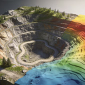
› Laser scanning (LiDAR) is a powerful modern method for fast and precise data collection, both for the natural and anthropogenic environment. It has wide applications in design, infrastructure construction, mining, forestry and agriculture, water management, archaeology and cultural heritage, etc.
› Preparation of orthophoto plans and maps at various scales and 3D models.